Woolhope Dome
On 4 May 2011 members of the Malvern U3A geology group met to undertake a field trip to the Woolhope Dome, led by Heather and David Hayward.
Report and pictures by Stuart Robinson
Introduction
This area takes its name from a rather isolated village enclosed within a ring of hills and the word hope means a blind valley. The main roads to Ledbury, Ross-on-Wye and Hereford give Woolhope a wide berth and so it is an ideal area for walking in the countryside. The western edge is marked by a flood plain formed by the River Wye and its tributaries the Lugg and the Frome, while the eastern edge is formed by the Marcle ridge with its prominent TV mast. A minor road ventures up into the hills from the west at Mordiford through Haugh Wood to Woolhope village and then retreats back down to Fownhope and the flood plain. Continuing around the hills in an anticlockwise direction other settlements around the edge are Sollers Hope in the south and Rushall in the east. There is a natural pass on the north east rim at Woolhope Cockshoot where five very minor roads converge. Stoke Edith and Upper Dormington complete the circuit back to Mordiford. The best parking place to explore the eastern part is at grid reference SO 630 346 (location 1 on the map) in a disused quarry on the scarp side of the ridge. The field trip explored only the eastern side of the dome, but Herefordshire and Worcestershire Earth Heritage Trust (EHT) publish a “Landscape and Geology Trail” covering the whole area using both a car and walking boots. You can purchase it from Herefordshire and Worcestershire Earth Heritage Trust; Geological Records Centre; University of Worcester; Henwick Grove; Worcester WR2 6AJ (01905 855184). A more technical resource is published by the British Geological Survey, “Geology of the country between Hereford and Ross-on-Wye”.
Map

Geology
The keys to understanding the geology of the Woolhope Dome are threefold.
(1) Alternating beds of limestones and shales were formed during the Wenlock and Ludlow epochs of
the Silurian period.
(2) The Silurian sequence of rocks was folded into an anticline, which as the name
suggests, was shaped rather like a dome.
(3) The anticline was subsequently unevenly eroded.

The simplified sketch illustrates the folding forming the anticline. Rocks originally laid down horizontally in strata during the Silurian period were pushed upwards by a central force during the Variscan Orogeny, folding the original strata into concentric arches while forcing the oldest rocks towards the surface at the centre. The dome is slightly asymmetrical because the dip is steeper on the west than the east. The stress was a maximum at the centre and progressively decreased outwards. Later in time all the surface rocks were gradually eroded by streams exposing rocks of different periods at the surface with the oldest at the centre and the youngest at the edges. The beds of rock are tilted at different angles and as a result the edges of the dome exhibit a dip and scarp topography with the latter facing inward and the former facing steeply outward. Because limestone is relatively harder it forms local in-lying hills and ridges while vales were left where the softer shales have been eroded. Old Red Sandstone from the Devonian period forms the landscape out-with the dome.
The original horizontal sediments were laid down in a marine environment in the following order known as the Silurian sequence. Each entry in the list below is an epochs (divisions) of the (Much) Silurian period.
Upper Ludlow Shales (youngest)
Aymestry Limestone
Lower Ludlow Shales
Wenlock Limestone
Coalbrookdale formation of shales
Woolhope Limestone
Haugh Wood Formations (oldest)
The Haugh Wood formations are beds of sandstones, mudstones, limestones and siltstones. After the upward thrust the entire original order of the sequence was preserved as a cross-section on the ground.
Brief Route Details
The field trip was based on a figure-of-eight route of about 6 km. From the car park follow the footpath down the scarp through woods to a track to Hyde Farm. Take the track up through Hyde Common and Busland Wood. Turn left beyond the wood at a T-junction to site b; retrace steps and continue to Hooper’s Oak. Now follow the path along the road northwards, turning right on the lane to Woolhope Cockshoot. Follow a minor road below the ridge to ‘The Wonder’. Turn up a holloway opposite a lane. Where it bears left follow the path above it back to Hooper’s Oak. Continue south back to the car park.

U3A geology group on Marcle ridge above car park (SO 630 346, location 1 on the map).
Sites of Interest
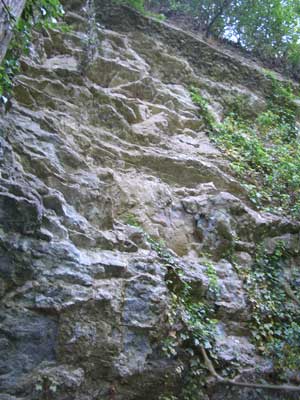
(a) Exposure of Aymestry Limestone
We first climbed onto the ridge above the quarry to observe the dip slope and the view east over the Leadon valley towards the Malvern Hills. The foreground consists of red-brown soil covering Old Red Sandstone from the Devonian period.
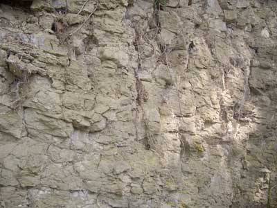
Exposure in the car park was heavily colonised but the adjacent cliff faces were clearer for study. Aymestry Limestone beds were thick with a thinner intervening layer unlike limestone in appearance. Overhangs of limestone followed the angle of the dip slope. There was no evidence of faults or displacement of strata though we did observe vertical veins of calcite which continued along overhangs and up the face. The original infill might have been Aragonite which was transformed naturally into calcite, the more stable bimorph. There was some apparent nodular limestone at the very top of the cliff face although it was only observed from below. Fossil corals have been reported in the limestone and brachiopods in the shale, but they were not evident on the day.
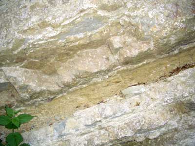
All pictures taken at SO 630 346, location 1 on the map
Band in the exposed limestone; old quarry adjacent to car park.
View up to top of quarry face showing nodular form of limestone in an overhang.
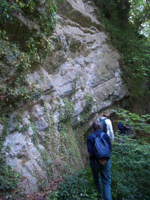
Overhangs indicate angle of dip slope and show strata.
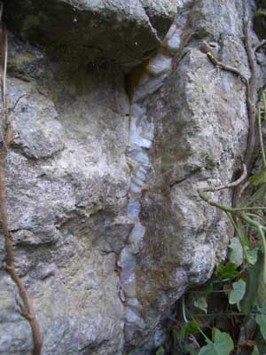
Vertical infill of calcite in quarry face. Notice that it continues around an overhang.
(b) Exposures of Much Wenlock Limestone

View to Seager Hill on the east outer rim from path (SO 627 343, location 2 on map).
Alan Gray found a bivalve on the track above Hyde Farm. Janet Parry spotted early purple orchids in the woods.
The main exposure at SO 623 354 (location 4 on the map) consists of thin bedded nodular limestone containing a few fossils, mainly brachiopods. The limestone of this small exposure was in contrast to that of the first site. This site offered excellent views of the ridge and vale topography. There is a disused limekiln nearby indicating that limestone was ‘mined’ and then decomposed into calcium oxide (quicklime) on site for spreading on fields.
Exposure of Wenlock limestone near Hyde farm (SO 623 344, location 3 on the map))

Group examines exposure of Much Wenlock limestone (SO 623 355, location 5 on the map).

On the Marcle Ridge going north to Woolhope Cockshoot. Joined Herefordshire trail at SO 630 354 (location 6 on map).
(c) Geological Fault at Woolhope Cockshoot (SO 631 371, location 7 on the map)
This is only one of several faults in the dome, but it is the most prominent. The pass at Woolhope Cockshoot between the north-eastern and southern ridges was formed by a fault where the Aymestrey Limestone to the north is higher than that to the south. There is also a distinct discontinuity in the alignment of the rim of the dome. This is especially noticeable on the geological map. The fault line runs approximately east north east to west south west (taken from the EHT guide) and is readily identifiable. The northeast ridge above Woolhope Cockshoot is highlighted on the OS 1:25,000 scale map by spot heights in metres: 224, 237, 269 (air survey), 264 (Seager hill trig point), 269 (air survey) and 259. On the other side of the pass the spot heights on the south ridge are: 209 (Green Hill Coppice), 193, 231 and 186 metres. If the fault line is extrapolated back into the dome it appears to originate in the centre. This suggested to me that it was a radial fault which might have been caused by the uplift. This seemed a reasonable hypothesis because the uplift could have fractured brittle rocks laid down millions of years ago. However, the geology is probably more complex.
The northeast ridge forms a water shed and streams to the southwest drain into the River Wye, while those on the opposite side ultimately drain into the River Severn. This site was also a good point to observe the hill and valley topography corresponding to limestone and shale rocks.
(d) The Wonder Landslip (SO 635 635, location 8 on the map)
There was a major landslip here in the 1570s. Bands of impervious bentonite clay within the Upper Ludlow Shales were saturated with water from streams and heavy rainfall. The hillside became unstable and slithered down the dip slope. The landslip was so destructive and the area so extensive that fully grown trees were uprooted and swept downwards together with a chapel, sheep and a sheepfold. They were all buried under the debris at the foot of the slope. A house nearby was later named The Wonder by Victorian sightseers. The house and the landslip site are both marked on the OS map, but there is now little to see on the ground because Nature has re-colonised the area. Hummocks in the ground indicated the location of some debris. An un-surfaced track briefly formed part of our return route. As we walked above and parallel to it there was a substantial and unnatural drop on the east side, estimated at about 3 metres. This suggested that the lane had possibly been cut into the debris leaving one side elevated.

Dirt Track at SO 633 365 (by location 8 on the map) near landslip known as The Wonder.
Glossary
Aymestry Limestone is named for the Roman settlement of Aymestrey in the Lugg valley in Herefordshire, where there are steep limestone scarps, though geologists dropped the final e.
Nodular means concretionary. The term is applied to rocks with a rounded external appearance.
Orogenesis means mountain building and orogeny is a general term for a period of mountain building. The Variscan Orogeny was a specific mountain building period which occurred at the end of the Carboniferous period when two super continents, Gondwana and Laurasia collided. The collision produced a new super continent Pangea and mountain chains across Europe by folding of rocks.
Polymorphism is the existence of different physical structures with identical chemical formulae, e.g. graphite and diamond.
Silurian period circa 439 to 408 Ma }
Devonian period circa 409 to 363 Ma } after Peter Toghill
Carboniferous period circa 362 to 289 Ma }
Shale is a fine-grained clastic sedimentary rock. It is comprised of layers of clay minerals and is fissile, i.e. easily broken down.